Kayak Beaufort for the Perfect View
Beaufort is surrounded by a labyrinth of rivers, estuaries, and islands. Beaufortonians grow up exploring their watery backyards, so they know which islands to camp on overnight and how to coordinate a summer day on a sandbar. If you want in on Beaufort’s secret, you have to play like the locals.
 Here’s a story about two locals out for a canoe trip to Cotton Island:
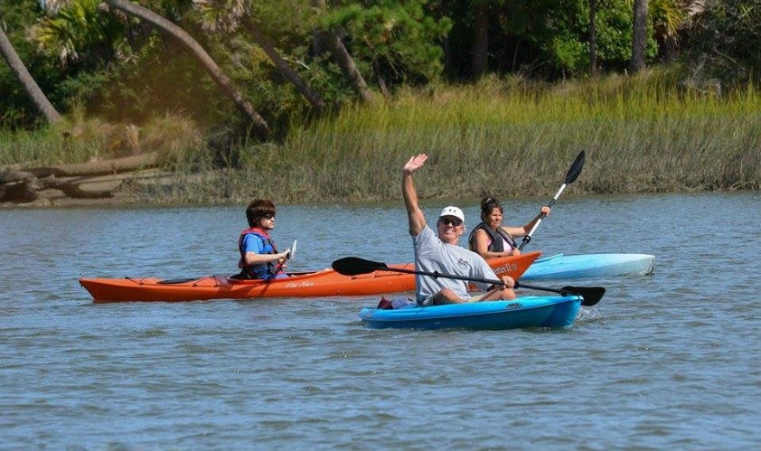
Our kayak, the Nucanoe Frontier 12’, is heavy to unload from the truck but we tote it down to the water where we begin to load up the supplies. This being the girls’ fishing trip, we were glad this spacious kayak-canoe hybrid could accommodate our female sense of packing. We laughed at  ourselves. So typical, we thought looking at the kayak loaded down and piled high with two life jackets, two fishing rods, a tackle box, bait bucket, cast net, large dry bag and cooler. The Nucanoe may have been a beast to lift in and out of the truck and into the water, but it was worth its wait in gold for its stability and space. I could step in, hang off and stand up without the kayak hardly rocking. Also, unlike most tandem kayaks, we had 360° mobility; we could face in the same direction to paddle or we could turn back-to-back to fish. We hit the water just before low tide around 10:30 a.m. and cracked open our first diet Coke of the day. We were Cotton Island bound.
The surrounding land of Clarendon Plantation was undeveloped; it was greenery and water as far as the eye could see. It had me wondering: how many uninhabited islands and pristine sandbars are there in the Beaufort area? Plenty I’m sure, but well-kept secrets of the locals.
We paddle up near an oyster bed on the lookout for minnows to catch as our bait. Leslie spots every moving thing in the muddy water including a horseshoe crab, a light-colored 3-foot shark and a huge stingray that glided under us in the Nucanoe. I was able to cast my net over a school of excited minnows standing up in the kayak. I didn’t catch any of them, but when we saw the hole in my net we knew why.
Of course, there are no worries on a sunny day in the Lowcountry. We cast our fishing lines a few times with Gulp before paddling out to the sandbar around the corner. Others were on the beach too, a few families with their children and dogs, but Leslie was surprised that there weren’t more boats out. I was surprised the infamous sandbar in downtown Beaufort wasn’t the only one that locals frequent in the summertime.
Before we knew it, it was 4 o’clock and the tide was coming in. The Nucanoe Frontier did us well and I would recommend to anyone looking to hang out, bring the dogs, booze cruise, hunt or fish as close to the water as it gets to check out this fine kayak at Higher Ground in Beaufort Town Center.
Staying on land we only scratch the surface of the beauty Beaufort beholds.
Here’s a list and a map of public boat landings. Make it your summer to-do list!
Public Boat Landings in Beaufort:
• Battery Creek (Parris Island) Landing. (Off State Road 802, on Battery Creek.)
• Beaufort City Marina Landing. (Bay Street, off Highway US 21, on the Beaufort River.)
• Brickyard Creek Landing. (End of County Road 72, off State Road 802, on Brickyard Creek.)
• Broad Creek Landing. (Off County Road 245, off Highway US 278, Hilton Head Island, on Broad Creek.)
• Broad River Landing. (Off State Road 170, on Broad River.)
• Buckingham Landing. (County Road 242 off Highway US 278, Karl Bowers Bridge, on Mackay Creek.)
• Butch’s Island Landing. (Off Highway US 21, St. Helena Island, on Ward’s Creek.)
• Capers Landing. (End of County Road 113, off County Road 45, St. Helena Island, on Capers Creek.)
• C.C. Haigh, Jr. Landing. (Off Highway US 278, Pinckney Island, on Mackay Creek.)
• Edgar C. Glenn Landing. (Off State Road 170, Lemon Island Bridge, on Chechessee River.)
• Fort Frederick Landing. (US Naval Hospital, on the Beaufort River.)
• Gray’s Hill Landing. (End of County Road 71, off Highway US 21, on Whale Branch Creek.)
• H.E. Trask, Sr. Landing. (End of County Road 744, Victoria Bluff, on Colleton River.)
• Johnson’s Creek Landing. (Off Highway US 21, Harbor Island, on Johnson’s Creek.)
• Paige Point Landing. (End of County Road 59, off Highway US 17, on Huspah Creek.)
• Pigeon Point Landing. (Pigeon Point Road, on the Beaufort River.)
• Port Royal Landing. (End of State Road 281, Port Royal, SC, on Battery Creek and Beaufort River.)
• Russ Point Landing. (Off County Road 406, Hunting Island State Park, on Fripp Inlet.)
• Sam’s Point Landing. (Off State Road 802, Lady’s Island, on Lucy Point Creek.)
• Station Creek Landing. (County Road 433, off County Road 77, St. Helena Island, on Station Creek.)
• Steel Bridge (Combated) Landing. (At Highway US 17, on Combated River.)
• Wallace Landing. (End of County Road 185, off County Road 45, St. Helena Island, on Haigh Creek.)
• White Hall Landing. (Off Highway US 21, Lady’s Island, on Factory Creek.)
• Wimbee Creek Landing. (Off County Road 43, off Highway US 17, on North Winbee Creek.)

Story by Tess Malijenovsky